
Are cloud visualization systems useful?
The application of aerial inspection for PV plants has gained widespread popularity. Several companies now specialize in aerial inspection data analysis services, helping optimize solar plant operations. In Taiwan, the use of drones for PV plant maintenance and management has steadily increased in recent years, enhancing efficiency and accuracy in system monitoring.
While the increasing use of aerial inspection for PV plants is a logical trend, it also presents challenges beyond drone selection and operator certification—particularly in data analysis and organization. For medium- and large-scale PV plants, the vast number of regularly arranged module arrays complicates the analysis and positioning of abnormal modules detected in thermal images. If multiple defects are present, engineers may require days or even longer to achieve accurate positioning. In many cases, the time spent on data analysis far exceeds the actual drone inspection time. Beyond positioning difficulties, presenting results is another major hurdle. Errors in system layout data or miscalculations in positioning may lead on-site personnel to dismantle the wrong modules, wasting time and resources. If inaccuracies persist, dissatisfaction grows, ultimately diminishing the value of aerial inspections. Additionally, manual reporting presents another issue—report formats and standards vary widely between individuals, making it difficult to compare reports over time. This inconsistency hinders efforts to track long-term PV plant degradation, missing crucial opportunities for preventive maintenance.
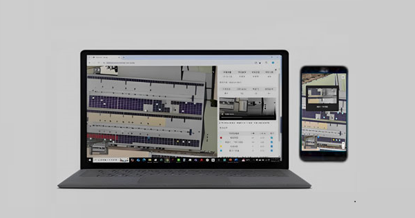
To address these challenges, AI-powered analysis has been introduced to standardize inspection criteria. By using orthophotos for anomaly positioning, errors can be minimized, allowing investigators to quickly locate abnormal modules via mobile devices and expedite the identification process. Another advantage of orthophoto-based positioning is its ability to document the installation environment of the PV plant, facilitating long-term analysis of environmental effects throughout the system’s 20-year lifespan. Additionally, one-click reporting enhances efficiency, while cloud-based data storage ensures accessibility anytime, significantly resolving key issues in PV plant aerial inspection.