
What is Orthophoto Mode Flight? Creating an Accurate Base Map
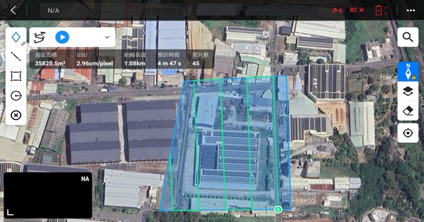
Orthophoto Mode refers to a method in which a UAV captures high-overlap visible-light images from a vertical top-down perspective. These images are processed using professional photogrammetry software for image stitching and geometric correction, producing a high-precision orthophoto map with true scale and accurate coordinate information. Through the IRUAV APP platform, users can clearly identify the exact position and coverage of each solar PV module, which serves as the base map for subsequent thermal defect marking and anomaly analysis. When performing an orthophoto mission, it is recommended to use UAVs equipped with a mechanical shutter (such as DJI M3E and DJI M4E) to avoid image distortion caused by electronic shutters, thereby improving stitching stability and positioning accuracy. The mission planning area should be larger than the actual module coverage area, and parallel flight lines should be used with at least three or more flight paths to ensure sufficient image overlap and consistent resolution. At the same time, buffer flight lines should be reserved outside the mission boundary to prevent missing coverage caused by GPS errors or insufficient stitching margins. After completing the orthophoto mission, an overall aerial photo of the entire site should be captured as a plant overview image, which is useful for reporting and on-site reference. Through this standardized orthophoto workflow, high-quality orthophoto imagery that is measurable and traceable can be obtained. This supports precise thermal defect localization and enables O&M personnel to quickly locate problematic modules in the field, significantly improving the inspection and maintenance efficiency of solar power plants.