
Is the cloud-based visualization system of Smart Solar O&M useful?
The use of thermal aerial inspections for PV systems has become increasingly common in advanced countries. Some companies now specialize in providing professional thermal aerial imaging and analysis services. In recent years, more and more people in Taiwan have also started using drones for the operation and maintenance of solar systems.
This is a reasonable trend, but at the same time, more and more people are realizing that beyond choosing the right drone and obtaining professional pilot licenses, the analysis and organization of the massive amount of inspection data after the flight is a major challenge. For medium to large-scale PV systems, which typically consist of a vast number of regularly arranged module arrays, thermal image anomalies pose issues in both analysis and accurate localization. When many thermal defects are present, ensuring precise localization can take engineers several days or even longer. In fact, the analysis workload often far exceeds the actual drone flight time. In addition to the challenge of labeling and mapping, the presentation of the results is another serious issue. If there are errors in the system’s module layout diagrams or mistakes in manual labeling and interpretation, on-site personnel may remove the wrong modules, wasting time and resources. Frequent errors can lead to serious dissatisfaction, rendering the thermal aerial inspection results meaningless. Another problem with manual reporting is that the report formats and standards vary depending on the person who creates them. This inconsistency makes it difficult to compare reports from different time periods, resulting in lost opportunities to monitor system degradation or maintenance trends over time.
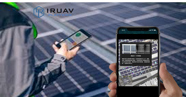
In response to the issues discussed above, the introduction of AI-based thermal defect analysis helps standardize inspection criteria, while the use of orthomosaic maps for anomaly labeling effectively prevents errors caused by mismatched module layout drawings. Field personnel can easily identify the exact location of abnormal modules using a mobile device, significantly reducing both the time required and the risk of errors when locating faulty modules. Another key advantage of orthomosaic-based annotation is that it simultaneously records the installation environment of the photovoltaic system, which is highly valuable for analyzing how environmental conditions affect power generation over the system’s 20-year operational lifespan. The cloud-based visualization system within Smart O&M fundamentally addresses all of the challenges mentioned above. Features such as one-click report generation and historical inspection comparisons are standard functions, while cloud-stored data allows users to access information anytime and anywhere. It effectively resolves the major pain points of thermal aerial inspection analysis. Users who have adopted the system have consistently provided positive feedback, and we sincerely invite you to experience it for yourself.